
A cluster of thunderstorms that meteorologists call a tropical disturbance was moving west across the far northern Gulf on Thursday, delivering scattered heavy rainfall over the central Gulf Coast. Rain was expected to continue into Friday.
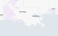
Southern Louisiana falls within the bull’s-eye of the storm activity, though New Orleans is likely to be spared from the heaviest rainfall.
“It doesn’t appear to be a huge impact to New Orleans, but this could change as sometimes forecasting the exact place of an individual thunderstorm can be difficult,” said Bob Oravec, a meteorologist with the Weather Prediction Center, which is part of the National Weather Service.
Key Things to Know
-
The storms are expected to drift north into southern Louisiana on Thursday evening. The National Hurricane Center said that chances were low that they would intensify into a tropical depression.
-
Regardless, there’s a chance for heavy rain in southern areas of Alabama, Mississippi and especially Louisiana in the coming days, with the rain most likely peaking on Thursday, continuing into Friday and lingering into Saturday.
-
Flood watches are in effect for southern Louisiana and far southern Mississippi. By Thursday afternoon, more localized flash flood warnings had been issued. While a flood watch means that conditions are favorable for flash flooding, a flood warning means that flooding is imminent or already happening.
A tropical disturbance is often the first stage in a tropical storm, but this system is not expected to intensify enough to become a named storm, and it’s unlikely to even become a tropical depression.